Friday, August 29, 2008

Day 21 Yellowstone National Park to Grand Teton National Park (Colter Bay Village)

August 29, 2008


Miles today - 46
Miles total - 1248
Elevation climbed - 1678 feet
Elevation at Colter Bay - 6877 feet
Ride time - 4 hours
Average speed - 11.4 mph


We left Yellowstone and entered into Grand Teton National Park. We had a fairly relaxed day on the bike and the weather was beautiful. Grand Teton National Park is located in northwestern Wyoming; south of Yellowstone National Park.


Thursday, August 28, 2008

Day 20 West Yellowstone to Yellowstone National Park (Grant Village)


August 28, 2008

Miles today - 60
Miles total - 1202
Elevation climbed - 2800 feet
Elevation at Yellowstone - 7700 feet
Ride time - 5 hours 22 mins
Average speed - 11.2 mph

Left West Yellowstone under cool clear skies with mild western winds (we are going east).  Riding in Yellowstone National Park was pleasant with a decent shoulder. There is very heavy vehicle traffic in the park even though most schools have resumed; the park ranger said many are Europians. Most of the drivers behaved and respected our rights as vehicles. We had two nice climbs passing over the Continental Divide twice with elevations over 8200 feet each.

We saw much wildlife today including bison and elk. The elk was in our campsite when we arrived and she bedded down for a couple hours before deciding to leave. 

We saw Old Faithful blow as well as a number of other geysers and boiling pools. Yellowstone NP has recovered nicely since the 1988 fire with millions of new trees.  Logpole pinecones released seed during fire so the recovery is pretty amazing.


Wednesday, August 27, 2008

Day 19 Cameron to West Yellowstone Montana

August 27, 2008

Miles today - 64
Miles total - 1142
Elevation climbed - 2774 feet
Elevation at West Yellowstone - 6400 feet
Average speed - 8.9 mph
Ride time 7 hours 10 mins

We left Cameron early trying to beat the winds; unsuccessfully. We fought fierce headwinds for about four hours down the Madison Valley. We averaged about 5 to 6 mph.  There was no services for about 40 miles, nowhere to rest out of the wind.

Entering into Yellowstone NP tomorrow and weather is improving.

Tuesday, August 26, 2008

Day 18 Twin Bridges to Cameron Montana

August 26, 2008

Miles today - 56
Miles total - 1078
Elevation climbed - 2792 feet
Elevation at Cameron - 5198 feet
Ride time - 4 hours 54 minutes
Average speed - 11.4 mph

Biked through the Ruby Valley early this morning following highway 287. -t was very beautiful and the morning light was great.  We passed through Nevada City (ghost town) and Virginia City and then climbed a 6700 foot pass. At the summit we had a beautiful view of the Madison Range and the Madison Valley. We decended quickly into the valley and passed through the town of Ennis before stopping at Cameron to camp.  Headwinds really kicked up the last twelve miles which slowed our progress.

Monday, August 25, 2008

Day 17 Jackson to Twin Bridges, Montana

August 25, 2008

Miles today - 80
Miles total - 1022
Ellevation climbed - 2239 feet
Elevation at Twin Bridges - 4773 feet
Ride time - 5 hours 31 minutes
Average speed - 14.3 mph

We climbed up and out of Big Hole Valley crestng the Big Hole Pass at 7360 feet; decended quickly and then up Badger Pass at 6730 feet before dropping down into Dillion Montana and pushing onward to Twin Bridges.

Winds were heavy today but thankfully we had them at our back MOST of the time.

Twin Bridges is in the Beaverhead area where Lewis and Clark expedition paused at a confluence of three tributaries naming them Philosophy, Wisdom and Philanthrophy; the then President's three virtues.... Later the rivers were renamed Willow Creek, Big Hole River and Ruby River.

Day 16 Darby to Jackson Montana

August 24, 2008

Miles today - 79
Miles total - 942
Elevation climbed - 4145 feet
Elevation at Jackson - 6251
Ride time 7 hours 25 minutes
Average speed - 10.8 mph

We rode out of the Bitterroot Valley and crossed the Continental Divide at Chief Joesph Pass. The pass tops out at 7241 feet. We decended into the Big Hole Valley. We passed through the town of Wisdom and onto Jackson.

Jackson has a population of about 35 but has a nice hot springs lodge. They have hiker/biker camping on premises; hot spring pool included.   We couldn't get the shower to have cool water; apparantly cold water is at a premium in the entire town. The lodge has a very good dinner menu. Not bad for a town of 35.

Saturday, August 23, 2008

Day 15 Missoula to Darby Montana

August 23, 2008
Miles today - 72
Miles total - 863
Elevation climbed - 1583 feet
Elevation at Darby - 3678 feet
Time riding - 6 hours 14 minutes
Average speed -11.5 mph

We had great weather today and a small tailwind traveling through the Bitterroot valley.

Friday, August 22, 2008

Day 14 Seele Lake to Missoula Montana

August 22, 2008
Miles today - 60
Miles total - 791
Elevation climbed - 1204 feet
Elevation at Missoula - 2953 feet
Ride time - 5 hours 6 Minutes
Average speed 11.8

Weather was dry, clear and crisp today. We fought a headwind most of the way but the route had some downhill sections.

We went to Adventure Cycling Association headquarters when we arrived in Missoula and then to dinner at Iron Horse.


Day 13 Swan Lake to Seele Lake

August 21, 2008
Miles today - 60
Miles total - 731
Elevation climbed - 2100 feet
Elevation at Seeley lake - 3700 feet
Ride time - 5 hours
Average speed 11.8

The rain continued through the night. It wasn't too windy so slept pretty well. Highway 83 runs through a sparesly settled area of Montana. The highway doesn't have a great shoulder for bicycles but the vehicles gave us room when passing.

Around 9am the rain lightened up so we quickly packed our gear and pushed on to Seeley Lake. This was the third day in a row riding in rain; at some points in the day the sky cleared but mostly rain. Milder weather on tap for tomorrow.

We had dinner at a place called Sauce's Place; our server sounded just like Jodi Foster.


Our campsite in Swan Lake

Thursday, August 21, 2008

Day 12 West Glacier to Swan Lake Montana

August 20, 2008
Miles today - 67
Total Miles - 671
Elevation climbed today - 1717 feet
Elevation at Swan Lake - 3126 feet
Ride time - 5 hours 36 minutes
Average speed - 11.8 mph

We left West Glacier early this morning. The goal was to ride to Columbia Falls and eat a hearty breakfast then push on to Swan Lake. The route map put us on quiet roads and traveling was nice until the rains started about four miles from Columbia Falls; we arrived at the local cafe pretty wet. The waitress offered us a dryer for our clothes.

During our breakfast the rain let up however about an hour after leaving Columbia Falls the rains started again and it did not stop during our ride to Swan Lake. It was was coming down hard but the temp was about 62f so it was too bad.

After arriving at Swan Lake we set up our tents in the rain. The local trading post has a laundry facility so we were able to dry out our clothes for tomorrow's ride - rain is predicated here in Big Sky country.

On route we had stopped to get a coffee and to get out of the elements at a gas station cafe and met a father and son from Wisconsin who were motor-biking for three weeks. They had traveled over 5500 miles thus far and were just heading home. They had some very interesting adventures during their travels. They had summited Logan's Pass on Going-to-the-sun road yesterday about 4 hours after we had and they got caught in the big storm that went through Glacier NP. They waited the storm out for a couple hours to let it subside.

Tuesday, August 19, 2008

Day 11 Rising Sun to West Glacier

August 19 2008
Miles total today - 46
Miles ridden total - 604
Elevation climbed - 2447 feet
Elavation at West Glacier - 3181 feet


We arose early and climbed to the rising sun. Not many vehicles on the road that early. Many photographers positioning for optimal light were present.


Going-to-the-Sun Road is the main parkway through the heart of Glacier National Park ; in Montana . This engineering marvel spans 50 miles through the park's wild interior, winding around mountainsides and treating visitors to some of the best sights in northwest Montana.

It was completed in 1932 , and it is the only road that crosses the park, going over the Continental Divide at Logan Pass. The road, a National Historic Landmark and a Historic Civil Engineering Landmark , spans 53 miles (85 km) across the width of the park.


The road is one of the most difficult roads in North America to snowplow in the spring. Up to 80 feet (25 m) of snow can lie on top of Logan Pass, and more just east of the pass where the deepest snowfield has long been referred to as Big Drift. The road takes about ten weeks to plow, even with equipment that can move 4000 tons of snow in an hour. The snowplow crew can clear as little as 500 feet (150 m) of the road per day. On the east side of the continental divide, there are few guardrails due to heavy snows and the resultant late winter avalanches that have repeatedly destroyed every protective barrier ever constructed. The road is generally open from early June to mid October.


The two lane Going-to-the-Sun Road is quite narrow and winding, especially west of Logan Pass. Consequently, vehicle lengths over the highest portions of the roadway are limited to 21 feet and that means no recreational vehicles or trailers in excess of this length restriction are permitted beyond two larger parking areas, each located at lower points dozens of miles below Logan Pass, on both the west and east sides of the parkway.


The road is named for Going to the Sun Mountain, which dominates the eastbound view beyond Logan Pass. One possibly apocryphal story tells of the deity Sour Spirit, who returned to the sun after teaching hunting to the Blackfeet, leaving his image on the mountain.

Day 10 St Mary to Glacier National Park Rising Sun Campground (Rest Day)

August 18, 2008
Miles ridden - 8
Total miles - 560
Elevation climbed today - 200 feet
Elevation at Glacier - 4390 feet
Ride time - 40  minutes
Average speed - 11.3 mph
Weather high - 96f
Weather low -50f

We are taking it easy today. We moved our camp site 8 miles closer to the climb for tomorrow. We are now inside Glacier NP at the. Rising Sun camp. The NP close the Going-To-The-Sun road to bikes from 11am - 4pm so we will be up early to climb it.

Day 9 Pincher Creek to St Mary

August 17, 2008
Miles ridden - 76
Total miles - 552
Elevation climbed today - 4840 feet
Elevation at St Mary - 4390 feet
Ride time - 7 hours 22 minutes
Average speed - 10.3 mph
Weather high - 96f
Weather low -50f


We started early once again from Pincher Creek; a quiet Sunday morning ride into Watertown National Park. Winds were not blowing much in southern Alberta plains but the heat rose quickly and was really hot by the time we started to climb out of Watertown NP.

Waterton is quiet, uncrowded National Park. It is the perfect place to view spectacular scenery, wildlife and enjoy outstanding recreational opportunities. A rare gem tucked into the southwestern corner of the province of Alberta, Canada. In this breathtaking part of the world, the majestic Rocky Mountains rise suddenly out of the rolling prairies. Amid the peaks are the lakes of Waterton Lakes National Park, carved out of the rock by ancient glaciers. Waterton is a tiny park; the total size is only 203 square miles. However, the park has great historical significance: based on more than 200 identified archaeological sites, historians think that Aborigines first populated the area 11,000 years ago.
 

Waterton Lakes National Park borders Glacier National Park in Montana to the south, together making up the Waterton-Glacier International Peace Park, the first of its kind in the world. A place like no other, the uniqueness of Waterton Park is a blend of unusual geology, mild climate, rare wild flowers, and an abundance of wildlife. It is a scene which has remained unchanged for centuries. 

We saw so many wildflowers from this seat of a bike.  On a hot climb to the border we saw a bear cross the road. When we reached the  summit a man who was driving in a motor home stopped and told us  he saw a baby grizzly bear cub.

We were pretty spent from the last days of riding so we will stop for a rest day tomorrow.

Saturday, August 16, 2008

Day 8. Fernie to Pincher Creek Alberta

Miles ridden 81
Miles total 475
Riding time 7 hours 4 minutes
Average speed 11.5 mph
Climbing elevation 3309 feet
Elevation at Pincher Creek 3500 feet

We left Fernie early because forecast was for triple digit heat. We rode into Fernie for coffee and saw that the finishline for the Trans Rockie Mt bike Race was being set up.  Later at the top of. Crowsnest pass we saw a check in station for the race so we mooched some water.

Crowsnest Pass (sometimes referred to as Crow's Nest Pass) (el. 1,358 m.) is a high mountain pass across the Continental Divide of the Canadian Rockies on the Alberta/British Columbia border.  Crowsnest Pass comprises a valley running east-west through Crowsnest Ridge. The Crowsnest River flows east from Crowsnest Lake, eventually draining into the Oldman River on the Alberta side. Summit Lake on the British Columbia side drains into the Elk River, which eventually feeds into the Kootenai and Kootenay Rivers, and finally into the Columbia River.

Riding along Elk river was very nice.

As predicated weather turned hot again and the wind off the Alberta plains made for slow riding into Pincher Creek.

Friday, August 15, 2008

Day 7 Waso to Fernie

August 15, 2008
Miles today - 82
Total Miles - 394
Elevation Climbed - 2842 feet
Elevation at Fernie - 3167 feet
Weather - 97f again
Ride time - 6 hours 50 minutes
Average mph - 11.8

We had planned an early start from Waso because the day was supposed to be another hot one. We were packed,  loaded and rolling by 7:30am.  We were also planning on having breakfast in Ft Steele but on our arrival found out it is a heritage town with just a few gift shops. We just settled for PBJ sandwiches.

Ft Steele is a nicely restired town. We feed three clydesdale horse some carrots.

The weather was again very hot so we stopped at the Elk River for a quick dip....wow that water is cold.

Fernie is a nice ski town resort but also is a mecca for mt bikers. We are camped at Fernie Prov  Park and the range said their hasn't been bears here is three weeks - comforting!

Day 6 Radium Hot Springs to Waso

August 14, 2008
Miles ridden today - 78
Total miles ridden - 310
Elevation climbed - 2300 feet
Elevation at Radium - 3050 feet
Weather - HOT 97f
Ride time 6 hours
Average 12.9 mph

Leaving Radium Hot Springs we traveled down through Invermere/Winermere valley  a nice, well to do town. Rode the west side road of the lake which is quiet and undevolped. We stopped in Invermere for some food and coffee.

The day was hot so after arriving at the town of Waso we jumped in the Waso lake to cool down.  Then found a nice fruit stand selling CA fruit for dinner.

Our camping neighbors were really nice. The couple was from Banff but had come down to west BC for the warm weather.  On our arrival to camp they brought us over two cold beers. Then later their young son brought us some oreo cookies. They are my new best friends! They were very interested in what it takes to do an extended self- supported bike tour.

Another hot day for tomorrow so we trying to push out early to beat the heat.

Thursday, August 14, 2008

Day 5 Castle Junction to Radium Hot Springs (Redstreak Campgrounds)


August 13, 2008 Miles Ridden
Today - 72 Total Miles Ridden - 244
Elevation climbed - 3259 feet
6.5 hours of riding time
Average speed - 11.4 mph
We left Banff National Park by climbing up Veremillion Pass and into Kootenay National Park. Half way up the climb we saw my Uncle coming the other way; he had been golfing in Invermere. Kootenay National Park is located in southeastern British Columbia Canada covering 1,406 km² (543 mi²) in the Canadian Rockies. The park ranges in elevation from 918 metres (3,011') at the south-west park entrance to 3,424 metres (11,235') at Deltaform Mountain. Kootenay forms one of the four contiguous mountain parks in the Canadian Rockies; the other three being Banff National Park directly to the east, Yoho National Park directly to the north and Jasper National Park; which does not share a boundary with Kootenay National Park. Initially called "Kootenay Dominion Park", the park was created in 1920 as part of an agreement between the province of British Columbia and the Canadian federal government to build a highway in exchange for title (property) to a strip of land on either side of the route. A strip of land 8 km. wide on each side of the newly constructed 94 km. Banff-Windermere Highway was set aside as a national park. While the park is open all year, the major tourist season lasts from June to September. Most campgrounds are open from early May to late September. The park takes its name from the Kootenay River one of the two major rivers which flow through the park, the other being the Vermillion River. While the Vermillion River is completely contained within the park, the Kootenay River has its headwaters just outside of the park boundary, flows through the park into the Rocky Mountain Trench; , eventually joining the Columbia River. The Banff-Windermere Highway, #93 follows the path of both rivers through the park.
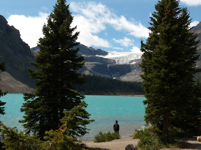
Something in the air shifted after riding into Kootenay National Park. Not exactly anything you could put your finger on but if I were to guess I'd say it was the magic of this area. The quiet warm air stretching across vast mountain ranges of forests. I felt that I might be impolite to disturb this area though I was happy to just pedal quietly within its confines. Vasts swathes of its forests were destroyed by fire; I felt as I was seeing a darker sadness of the forest looking at the fire's destruction while also feeling its hope by seeing bits of green striving to survive.

The river was beautiful and it offered coolness as I rode next to it. Its powerful rush called to me as I rode next to it. As it snaked down the mountain the river went in and out of shade constantly calling me into its snow melt freezing water. Who could resist? The feeling of the cold water and the hot sun; having the river flow over the skin of my feet can't be described by words but it a feeling that will remain in my mind forever.


Okay - so which way do we go??

Wednesday, August 13, 2008

Day 4. Waterfowl to Castle Junction

August 12, 2008
Miles ridden today - 60
Miles ridden total - 172
Elevation feet climbed today - 2700 feet
Temperture at Waterfowl - 0 c. 32f
Weather- clear
Bow Pass summit - 6500 feet

Woke to a very cold morning. We wanted to get an early start to tackle Bow Pass but it was freezing! The park service has neat cookhouses in the campgrounds so Craig whipped up some breakfast on the stove and we hung out waiting for the weather to warm up. We got on the road about 11am

After the climb up Bow Pass we decended into into Lake Louise area where we had some lunch and bought provisions for dinner. We had mexican theme. Craig is a gourmet chef!! Once again we snagged a camp site next cookhouse at the Castle Junction campground.

Lake Louise is abit too touristy for my taste and they really gouge you on everything. The real draw of it is the natural beauty.

We saw another bear today. Tourist were outside their vehicle snapping pictures! The bear had a collar on but I am not sure the purpose of it. At Waterfowl camp there is a bear called number 7; just tell him "go away Number 7" and he will leave your camp. We have been storing the food in bear lockers of course.


Tuesday, August 12, 2008

Day 3 Jonas Creek to Waterfowl Campground

August 11, 2008
Distance ridden today - 62 miles
Total Distance - 112 miles
Climbing elevation - 3500 feet
Elevation at Waterfowl - 5100 feet

We were going to try and leave Jonas Creek at 9am and climb the Sunwapta Pass but the rain start falling very heavy in the middle of the night and continued until around 10am.

We had breakfast in an open coved cookhouse and we meet some nice fellow bikers from BC and Melbourne. It was the smells of their cooking that actually woke me up.


After drying out we finally got our gear pack, though still somewhat wet and we were on the road by 11am. We were once again met with magnificant vistas, absolutely stunning!


We climbed up Sunwapta Pass which summited at 6700 feet. Lugging a 80 pound bike up a gradient of 10% makes for slow going. At the summit I was travelling at 3 miles an hour. A woman at the summit who had stopped to take some pictures ran out into the road and snapped my picture and said 'you are amazing'. Thanks I said.


Day 2 Jasper to Jonas Creek


August 10, 2008

Miles ridden today - 50
Total climbing elevation - 3100 feet
Average climbing gradient 2%
Elevation at Jonas Creek - 5000 feet

We woke to rain in the early morning so I stayed in bed as long as possible. The rain finally subsided. After some breakfast we broke camp. After months of planning and hundreds of dollars spent we were finally logging our first miles.


The rain started again about an hour from Jonas Creek. While the rain gear and fenders worked well it is never fun to ride in the rain. It lasted about an hour; right before we arrived at Jonas Creek.

We traveled along Highway 93A to Athabasca Falls, it is just 23 metres high. However, it is not known for its height. Instead it is known for the force of the falling water due to the quantity of water flowing. Even on a cold morning in the fall, copious amounts of water flow over the falls.


Check out my video of Athabasca Falls


Ready to Ride the Icefield Parkway


Paying to Ride the Icefield Parkway - $10 each day - Each!


On the quiet Highway 93A alternative


Storm Clouds rolling in


Arriving in Jonas Creek Campground wet

Life is...

Life is an opportunity, benefit from it.
Life is beauty, admire it.
Life is a dream, realize it.
Life is a challenge, meet it.
Life is a duty, complete it.
Life is a game, play it.
Life is a promise, fulfill it.
Life is sorrow, overcome it.
Life is a song, sing it.
Life is a struggle, accept it.
Life is a tragedy, confront it.
Life is an adventure, dare it.
Life is luck, make it.
Life is too precious, do not destroy it.
Life is life, fight for it.

- Mother Theresa


Sunday, August 10, 2008

The Wing

Your desire for an illusion is like a wing.
This wing will take you to Reality...
Preserve the wing; do not feed the desire
this wing of desire will take you to Paradise.
People think they are enjoying themselves: in reality they are tearing their wings apart for the sake of an imaginary form.

-Jalaluddin Rumi


Saturday, August 9, 2008

Day 1 - Jasper

No riding today.

I received a nice gift from my aunt and uncle along with some tasty brownies for our trip.

It was about and 3 hour drive from Edmonton to Jasper. Of course we stopped at Tim Hortons for lunch. Only in Canada would a fast-food chain be named after a hockey player. Craig didn't know what a double-double was. "Double-Double" is a colloquial term in Canada for Tim Horton's coffee with two creams and two sugars.


We met Craig's family in Jasper. They scored a camp site at Whistler campground in Jasper so we stay with them for the night.

Jasper is a nice comfortable town of around 4500 people but tourist traffic is pretty heavy this time of the year.

The bike reassembly went well with no damage to the bike this morning; will shake it out tomorrow on the Icefield Parkway. I know it will be fine once I start but I can't shake the uneasy feeling something is damaged.

We went to the Jasper visitor center which is the formal start of the Great Parks ride.

It stays light until 9:45pm here in the Northwest; more time for riding. There was some light rain today but nothing significant.


Day 1. Bright and early

The sun rises early here in Edmonton. Partly cloudy with crisp air.

We will take some time to reassemble the bikes and load the panniers and then off to Jasper.  Uncle says it is three hours to the Icefields Parway.

The Parkway stretches 144 miles between Jasper and Lake Louise. It is called the heart of the Canadian Rockies.

Day 1 Edmontonr


 At my Uncle and Aunt's house in Edmonton.  I arrived late in the night but   will be up early today and on the road to Jasper.  I wish I had some more time to spend here but I am itching to ride my bike.

All the equipment arrived safety at least I think so;  though it is too late to assemble the bikes to check for damage.

my Aunt Mary is making brownies and the house smell yummy.

Edmonton is the capital of the Canadian province of Alberta. The city is located on the North Saskatchewan River in the central region of the province, an area with some of the most fertile farmland on the prairies. It is the second largest city in Alberta, with a population of about 750,000. My uncle tells me that it is more like 1000000 people with outline area.

We are fairly close to the river..

More blog tommorrow on my way to Jasper.

As always please leave your comments.


Friday, August 8, 2008

08/08/08 Let the fun begin!!!


My Great Parks bike trip officially begins on 08/08/08 at 8pm. My plane is scheduled to depart on that date and time. I think that’s pretty cool!!

The 08/08/08 date is not only cool looking but the number 8 is also considered very favorable in Chinese culture. The Chinese pronunciation for ‘eight’ (ba in Mandarin and paat in Cantonese) sounds similar to the word for ‘prosperity’ (fa in Mandarin and faat in Cantonese). The more eights involved the better chance one will have for luck and wealth.

The summer Olympics in Beijing will begin on 8/8/08, at 8:08 p.m. Along with the good luck associated with the number eight, 8/8/08 has a few other factors that might make it a fun day. The numeral “8″ is turned on its side, it becomes the symbol for infinity – okay that reaching a bit; but its cool!

My wife has made me a friendship bracelet embroidered with '8 8 8' to wear on my ride...way cool!

Please note the time of this post..... Cool!


Haiku by Grace


The rain is falling
My hair is wet from the drops
Water filled the creek